Fix:Amurrivermap.png

Grandia de esta previde: 761 × 599 pixeles Otra densias: 305 × 240 pixeles | 610 × 480 pixeles | 989 × 779 pixeles.
Fix orijinal (989 × 779 pixeles, grandia de fix: 298 KB, tipo MIME: image/png)
| Descrive |
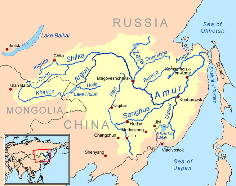
English: This is a map of the Amur River drainage basin. Русский: Карта бассейна реки Амур. |
| Data | |
| Fonte | Own work using Digital Chart of the World and GTOPO data. |
| Autor | Kmusser |
| Other versions |
Derivative works of this file: Amurriversourcesmap.jpg File:Amur watershed.png |
I, the copyright holder of this work, hereby publish it under the following license:
Esta fix es lisensada su la lisensa Attribution-Share Alike 3.0 Unported de Creative Commons.
- Tu es libre:
- per comparti – per copia, distribui e transmete la obra
- per remisca – per ajusta la obra
- Su la constrinjes seguente:
- atribui – Tu debe atribui la obra en la modo spesifada par la autor o lisensor (ma no en cualce modo cual sujesta ce el aproba tu o tua usa de la obra).
- share alike – Si tu altera, muta o developa plu esta obra, tu pote distribui la obra resultante sola su la mesma lisensa o un simil a esta.

|
This map image could be re-created using vector graphics as an SVG file. This has several advantages; see Commons:Media for cleanup for more information. If an SVG form of this image is available, please upload it and afterwards replace this template with
{{vector version available|new image name}}.
It is recommended to name the SVG file “Amurrivermap.svg”—then the template Vector version available (or Vva) does not need the new image name parameter. |
Istoria de fix
Clica un data/ora per vide la fix en sua forma de alora.
| Data/Ora | Imajeta | Mesuras | Usor | Comenta | |
|---|---|---|---|---|---|
| aora | 01:15, 7 junio 2010 | | 989 × 779 (298 KB) | Ras67 | cropped |
| 20:05, 2 marto 2009 |  | 1,000 × 795 (367 KB) | Kmusser | {{Information |Description=This is a map of the Amur River drainage basin. |Source=Own work using [http://www.maproom.psu.edu/dcw/ Digital Chart of the World] and [http://edc.usgs.gov/products/elevation/gtopo30/gtopo30.html GTOPO] data. |
Usas de fix
La paje seguente lia a esta fix:
Usa global de fix
La otra vicis seguente usa esta fix:
- Usa en af.wikipedia.org
- Usa en als.wikipedia.org
- Usa en ar.wikipedia.org
- Usa en arz.wikipedia.org
- Usa en ast.wikipedia.org
- Usa en azb.wikipedia.org
- Usa en be-tarask.wikipedia.org
- Usa en bg.wikipedia.org
- Usa en bh.wikipedia.org
- Usa en bn.wikipedia.org
- Usa en br.wikipedia.org
- Usa en bs.wikipedia.org
- Usa en ca.wikipedia.org
- Usa en cy.wikipedia.org
- Usa en da.wikipedia.org
- Usa en de.wikipedia.org
- Usa en en.wikipedia.org
- Usa en eo.wikipedia.org
- Usa en es.wikipedia.org
Mostra plu usas global de esta fix.