Fix:British Columbia-map.png
No densia plu alta es disponable.
British_Columbia-map.png (280 × 230 pixeles, grandia de fix: 14 KB, tipo MIME: image/png)

|
File:British Columbia, Canada.svg is a vector version of this file. It should be used in place of this PNG file when not inferior.
File:British Columbia-map.png → File:British Columbia, Canada.svg
For more information, see Help:SVG. |
 |
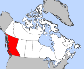
Map of British Columbia
Projection: Lambert azimuthal equal-area
Geospatial data from: The Atlas of Canada, The National Atlas of the United States archive copy at the Wayback Machine and U.S. Geological Survey
Cartographer: John Fowler
| I, the copyright holder of this work, release this work into the public domain. This applies worldwide. In some countries this may not be legally possible; if so: I grant anyone the right to use this work for any purpose, without any conditions, unless such conditions are required by law. |
Istoria de fix
Clica un data/ora per vide la fix en sua forma de alora.
| Data/Ora | Imajeta | Mesuras | Usor | Comenta | |
|---|---|---|---|---|---|
| aora | 12:12, 24 marto 2005 | | 280 × 230 (14 KB) | Voyager | Map of British Columbia Projection: Lambert azimuthal equal-area Geospatial data from: [http://atlas.gc.ca/ The Atlas of Canada], [http://www.nationalatlas.gov/ The National Atlas of the United States] and [http://www.usgs.gov U.S. Geological Survey] C |
Usas de fix
No pajes lia a esta fix.
Usa global de fix
La otra vicis seguente usa esta fix:
- Usa en fr.wikipedia.org
- Usa en he.wikivoyage.org