Fix:End.of.Roman.rule.in.Britain.383.410.jpg

Fix orijinal (2,582 × 3,220 pixeles, grandia de fix: 1,010 KB, tipo MIME: image/jpeg)
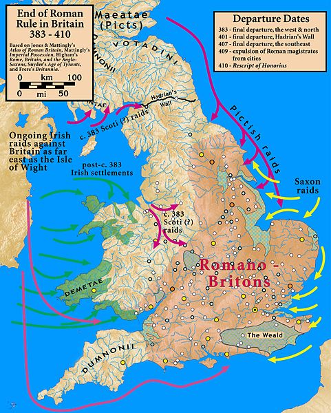
| Descrive | End of Roman Rule in Britain, 383–410 |
| Data | |
| Fonte |
Based on Jones & Mattingly's Atlas of Roman Britain (ISBN 978-1-84217-06700, 1990, reprinted 2007); Mattingly's Imperial Possession ( ISBN 978-0-140-14822-0, 2006); Higham's Rome, Britain, and the Anglo-Saxons (ISBN 1-85264-022-7, 1992); Frere's Britannia (ISBN 0-7102-1215-1, 1987); and Snyder's An Age of Tyrants (ISBN 978-0-631-22260-6) — the sources are cited in the image legend — Locations of towns (fortified and unfortified) are given on p. 156, with tribal civitates and coloniae specified on p. 154, of Atlas of Roman Britain. Specification of the Romanized regions of Britain are also from the Atlas, p. 151. The "Departure Dates" are found in the cited sources, and are generally known. The Pictish, Saxon, and Scoti raids are found in the cited sources, as is the date of the Irish settlements in Wales. Frere suggests (p. 355) that it was the Irish who sacked Wroxeter c. 383. The locations of the Irish settlements is from the locations of inscription stones given in File:Britain.Deisi.Laigin.jpg as of 2010-10-11, which cites its sources of information.
|
| Autor | my work |
- Tu es libre:
- per comparti – per copia, distribui e transmete la obra
- per remisca – per ajusta la obra
- Su la constrinjes seguente:
- atribui – Tu debe atribui la obra en la modo spesifada par la autor o lisensor (ma no en cualce modo cual sujesta ce el aproba tu o tua usa de la obra).
- share alike – Si tu altera, muta o developa plu esta obra, tu pote distribui la obra resultante sola su la mesma lisensa o un simil a esta.

|
This historical map image could be re-created using vector graphics as an SVG file. This has several advantages; see Commons:Media for cleanup for more information. If an SVG form of this image is available, please upload it and afterwards replace this template with
{{vector version available|new image name}}.
It is recommended to name the SVG file “End.of.Roman.rule.in.Britain.383.410.svg”—then the template Vector version available (or Vva) does not need the new image name parameter. |


Istoria de fix
Clica un data/ora per vide la fix en sua forma de alora.
| Data/Ora | Imajeta | Mesuras | Usor | Comenta | |
|---|---|---|---|---|---|
| aora | 20:07, 18 otobre 2010 | | 2,582 × 3,220 (1,010 KB) | Notuncurious | {{Information |Description=End of Roman Rule in Britain, 383–410 |Source=Based on Jones & Mattingly's ''Atlas of Roman Britain'' (ISBN 978-1-84217-06700, 1990, reprinted 2007); Mattingly's ''Imperial Possession'' ( ISBN 978-0-140-14822-0, 2006); Hig |
Usas de fix
La pajes seguente lia a esta fix:
Usa global de fix
La otra vicis seguente usa esta fix:
- Usa en ar.wikipedia.org
- Usa en ast.wikipedia.org
- Usa en be.wikipedia.org
- Usa en bn.wikipedia.org
- Usa en ca.wikipedia.org
- Usa en da.wikipedia.org
- Usa en en.wikipedia.org
- Usa en es.wikipedia.org
- Usa en et.wikipedia.org
- Usa en fa.wikipedia.org
- Usa en fr.wikipedia.org
- Usa en gl.wikipedia.org
- Usa en hr.wikipedia.org
- Usa en it.wikipedia.org
- Usa en ja.wikipedia.org
- Usa en pnb.wikipedia.org
- Usa en pt.wikipedia.org
- Usa en ro.wikipedia.org
- Usa en ru.wikipedia.org
- Usa en sh.wikipedia.org
- Usa en sr.wikipedia.org
- Usa en tr.wikipedia.org
- Usa en ur.wikipedia.org
- Usa en www.wikidata.org
- Usa en zh.wikipedia.org