Fix:Flusssystemkarte Rhein 04.jpg

Grandia de esta previde: 441 × 599 pixeles Otra densias: 177 × 240 pixeles | 353 × 480 pixeles | 565 × 768 pixeles | 754 × 1,024 pixeles | 1,508 × 2,048 pixeles | 3,198 × 4,344 pixeles.
Fix orijinal (3,198 × 4,344 pixeles, grandia de fix: 11.72 MB, tipo MIME: image/jpeg)
Resoma
| Descrive |
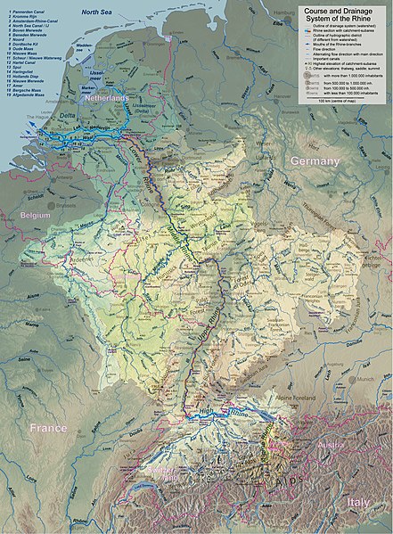
English: Rhine course and river system, place names in English Deutsch: Rheinlauf und Flusssystem, englisch beschriftet Français : Cours du Rhin et son bassin versant, noms de lieux en anglais Nederlands: Verloop en rivierensysteem van de Rijn, plaatsnamen in Engels |
| Data | |
| Fonte | Obra propre |
| Autor | WWasser |
| Other versions | Versions in german, french, dutch, or with local names. For other languages the unlabelled version may be used. There are also less detailed maps of the river system with either german, english, french, dutch, or local names. A small version without names is available, too. |
| Camera location | | View this and other nearby images on: OpenStreetMap |
|---|
- Background relief created with Google Maps-For-Free SRTM3 Webserver
- Topography derived from Open Street Map
- Outlines of catchment areas derived from relief data (in the Netherlands also taken from several ICPR (International Commission for the Protection of the Rhine)- and Rijkswaterstaat-publications)
Lisensa
I, the copyright holder of this work, hereby publish it under the following license:
Esta fix es lisensada su la lisensa Attribution-Share Alike 3.0 Unported de Creative Commons.
- Tu es libre:
- per comparti – per copia, distribui e transmete la obra
- per remisca – per ajusta la obra
- Su la constrinjes seguente:
- atribui – Tu debe atribui la obra en la modo spesifada par la autor o lisensor (ma no en cualce modo cual sujesta ce el aproba tu o tua usa de la obra).
- share alike – Si tu altera, muta o developa plu esta obra, tu pote distribui la obra resultante sola su la mesma lisensa o un simil a esta.
Istoria de fix
Clica un data/ora per vide la fix en sua forma de alora.
| Data/Ora | Imajeta | Mesuras | Usor | Comenta | |
|---|---|---|---|---|---|
| aora | 18:26, 17 setembre 2017 | | 3,198 × 4,344 (11.72 MB) | WWasser | Albertkanaal, Aa (Dommel), frontier lines in Lake of Constance |
| 12:23, 18 april 2013 |  | 2,399 × 3,255 (4.7 MB) | WWasser | more details | |
| 16:34, 4 april 2013 |  | 2,131 × 2,892 (4.22 MB) | WWasser | {{Information |Description ={{en|1=legend and colours, more toponyms translated}} |Source =own work |Author =own work |Date = |Permission = |other_versions = }} | |
| 13:49, 5 marto 2013 |  | 2,131 × 2,894 (3.32 MB) | WWasser | some smaller rivers, elevations | |
| 12:56, 8 febrero 2013 |  | 2,131 × 2,896 (3.07 MB) | WWasser | {{Information |Description ={{en|1=colours improved}} |Source =own |Author =WWasser |Date = |Permission = |other_versions = }} | |
| 09:03, 8 febrero 2013 |  | 2,131 × 2,896 (3.11 MB) | WWasser | {{Information |Description ={{en|1=lower, more appropriate resolution}} |Source =own |Author =User:WWasser|WWasser |Date =2013-02-05 |Permission = |other_versions = }} | |
| 16:04, 5 febrero 2013 |  | 4,262 × 5,791 (4.22 MB) | WWasser | User created page with UploadWizard |
Usas de fix
La paje seguente lia a esta fix:
Usa global de fix
La otra vicis seguente usa esta fix:
- Usa en ang.wikipedia.org
- Usa en ast.wikipedia.org
- Usa en as.wikipedia.org
- Usa en av.wikipedia.org
- Usa en azb.wikipedia.org
- Usa en ban.wikipedia.org
- Usa en ba.wikipedia.org
- Usa en be-tarask.wikipedia.org
- Usa en be.wikipedia.org
- Usa en bh.wikipedia.org
- Usa en da.wikipedia.org
- Usa en en.wikipedia.org
- Usa en fa.wikipedia.org
- Usa en gv.wikipedia.org
- Usa en he.wikipedia.org
- Usa en hi.wikipedia.org
- Usa en id.wikipedia.org
- Usa en ilo.wikipedia.org
- Usa en kk.wikipedia.org
- Usa en kw.wikipedia.org
- Usa en lij.wikipedia.org
- Usa en ml.wikipedia.org
- Usa en nl.wikipedia.org
- Usa en ru.wikipedia.org
- Usa en sco.wikipedia.org
- Usa en sd.wikipedia.org
- Usa en simple.wikipedia.org
- Usa en th.wikipedia.org
- Usa en tr.wikipedia.org