Fix:FrobisherBayOMC.png
No densia plu alta es disponable.
FrobisherBayOMC.png (496 × 496 pixeles, grandia de fix: 17 KB, tipo MIME: image/png)
Resoma
| Descrive |
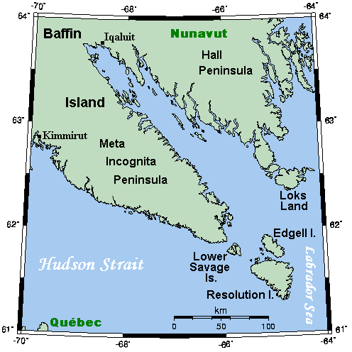
English: A map showing Frobisher Bay and nearby areas. This map's source is here, with the uploader's modifications, and the GMT homepage says that the tools are released under the GNU General Public License. |
| Data | 12 julio 2007 (original upload date) |
| Fonte | Transferred from en.wikipedia to Commons. |
| Autor | Kelisi at English Vicipedia |
Lisensa
Kelisi from en.wikipedia.org, the copyright holder of this work, hereby publishes it under the following license:
| Esta fix es lisensada su la lisensa de Creative Commons Attribution-Share Alike 3.0 Unported Subject to disclaimers. | ||
| Atribui: Kelisi from en.wikipedia.org | ||
| ||
| This licensing tag was added to this file as part of the GFDL licensing update. |

|
Permete es donada per copia, distribui e/o altera esta documento su la restrinjes de la GNU Free Documentation License, Varia 1.2 o cualce varia plu tarda publicida par la Free Software Foundation, sin partes nonvariante, sin testo de covrente fronte e sin testo de covrente retro. Un copia de la lisensa es incluida en la parte nomida GNU Free Documentation License. Subject to disclaimers. |
Original upload log
The original description page was here. All following user names refer to en.wikipedia.
- 2007-07-12 19:16 Kelisi 496×496×8 (17371 bytes)
- 2007-07-12 16:43 Kelisi 493×496×8 (16903 bytes) == Summary == A map showing Frobisher Bay and nearby areas. This map's source is [http://www.aquarius.ifm-geomar.de/ here], with the uploader's modifications, and the [http://gmt.soest.hawaii.edu/ GMT homepage] says that the tools are released under the G
Istoria de fix
Clica un data/ora per vide la fix en sua forma de alora.
| Data/Ora | Imajeta | Mesuras | Usor | Comenta | |
|---|---|---|---|---|---|
| aora | 17:58, 10 julio 2008 | | 496 × 496 (17 KB) | Urdangaray | {{Information |Description={{en|A map showing Frobisher Bay and nearby areas. This map's source is [http://www.aquarius.ifm-geomar.de/ here], with the uploader's modifications, and the [http://gmt.soest.hawaii.edu/ GMT homepage] says that the tools are re |
Usas de fix
La paje seguente lia a esta fix:
Usa global de fix
La otra vicis seguente usa esta fix:
- Usa en ca.wikipedia.org
- Usa en ckb.wikipedia.org
- Usa en da.wikipedia.org
- Usa en de.wikipedia.org
- Usa en en.wikipedia.org
- Usa en es.wikipedia.org
- Usa en fa.wikipedia.org
- Usa en hu.wikipedia.org
- Usa en it.wikipedia.org
- Usa en ja.wikipedia.org
- Usa en ml.wikipedia.org
- Usa en nn.wikipedia.org
- Usa en no.wikipedia.org
- Usa en www.wikidata.org