Fix:Germanic tribes (750BC-1AD).png
No densia plu alta es disponable.
Germanic_tribes_(750BC-1AD).png (537 × 376 pixeles, grandia de fix: 10 KB, tipo MIME: image/png)
.png)
Resoma

|
File:Germanic tribes settlements 750BC-1AD.svg is a vector version of this file. It should be used in place of this PNG file when not inferior.
File:Germanic tribes (750BC-1AD).png → File:Germanic tribes settlements 750BC-1AD.svg
For more information, see Help:SVG. |
 |
| Descrive |
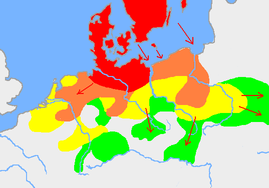
English: Based on p. 108 in the Penguin Atlas of World History, volume 1, from the Beginning to the Eve of the French Revolution. 1988. ISBN 0-14-051054-0. Note that the map assumes that the Nordwestblock was Germanized before 500 BC. This is uncertain; alternative proposals hold that the area near the mouths of the Rhine came under a Germanic superstate only in the 1st century BC.
The map is drawn on en:User:Dbachmann's blank map: en:Image:Europe plain rivers.png Settlements before 750 bc
New settlements by 500 bc
New settlements by 250 bc
New settlements by ad 1
Archived copy of a version of the original map. |
| Data | 21 janero 2007 (original upload date) |
| Fonte | Transferred from en.wikipedia to Commons. |
| Autor | Berig at English Vicipedia |
see also Image:Pre Migration Age Germanic.png
Lisensa
I, Berig, the copyright holder of this work, hereby publishes it under the following licenses:

|
Permete es donada per copia, distribui e/o altera esta documento su la restrinjes de la GNU Free Documentation License, Varia 1.2 o cualce varia plu tarda publicida par la Free Software Foundation, sin partes nonvariante, sin testo de covrente fronte e sin testo de covrente retro. Un copia de la lisensa es incluida en la parte nomida GNU Free Documentation License. |
| Esta fix es lisensada su la lisensa Attribution-Share Alike 3.0 Unported de Creative Commons. | ||
| Atribui: I, Berig | ||
| ||
| This licensing tag was added to this file as part of the GFDL licensing update. |
This file is licensed under the Creative Commons Attribution 2.5 Generic license.
Atribui: I, Berig
- Tu es libre:
- per comparti – per copia, distribui e transmete la obra
- per remisca – per ajusta la obra
- Su la constrinjes seguente:
- atribui – Tu debe atribui la obra en la modo spesifada par la autor o lisensor (ma no en cualce modo cual sujesta ce el aproba tu o tua usa de la obra).
Tu pote eleje la lisensa cual tu prefere
Original upload log
The original description page was here. All following user names refer to en.wikipedia.
- 2007-01-21 10:52 Berig 537×376×8 (18448 bytes) Based on p. 108 in the Penguin Atlas of World History, volume 1, from the Beginning to the Eve of the French Revolution. 1988. The map is drawn on [[User:Dbachmann]]'s blank map: [[:Image:Europe plain rivers.png]]
Istoria de fix
Clica un data/ora per vide la fix en sua forma de alora.
| Data/Ora | Imajeta | Mesuras | Usor | Comenta | |
|---|---|---|---|---|---|
| aora | 00:34, 17 febrero 2009 | | 537 × 376 (10 KB) | Disposable.Heroes | pngcrush |
| 17:17, 11 marto 2007 |  | 537 × 376 (18 KB) | R9tgokunks | {{Information |Description=Based on p. 108 in the Penguin Atlas of World History, volume 1, from the Beginning to the Eve of the French Revolution. 1988. ISBN 0-14-051054-0 The map is drawn on en:User:Dbachmann's blank map: [[:en::Image:Europe plain | |
| 20:17, 11 febrero 2007 |  | 537 × 376 (18 KB) | Electionworld | {{Information |Description=Based on p. 108 in the Penguin Atlas of World History, volume 1, from the Beginning to the Eve of the French Revolution. 1988. ISBN 0-14-051054-0 The map is drawn on en:User:Dbachmann's blank map: [[:en::Image:Europe plain |
Usas de fix
La pajes seguente lia a esta fix:
Usa global de fix
La otra vicis seguente usa esta fix:
- Usa en af.wikipedia.org
- Usa en ar.wikipedia.org
- Usa en ast.wikipedia.org
- Usa en av.wikipedia.org
- Usa en azb.wikipedia.org
- Usa en bg.wikipedia.org
- Usa en bn.wikipedia.org
- Usa en bs.wikipedia.org
- Usa en ca.wikipedia.org
- Usa en ckb.wikipedia.org
- Usa en cv.wikipedia.org
- Usa en de.wikipedia.org
- Usa en el.wikipedia.org
- Usa en en.wikipedia.org
- Bastarnae
- Celts
- Germanic languages
- Germanic peoples
- History of Germany
- History of the Netherlands
- Lombards
- AD 1
- 250 BC
- Marchian
- Eastphalian language
- Proto-Germanic language
- Ruhrdeutsch
- East Germanic languages
- Talk:Germania
- Benrath line
- Lexin
- Vadstena bracteate
- Svealand dialects
- Leew Eilun Feer
- South Franconian German
- Highest Alemannic German
- Moselle Franconian language
- Stellingwarfs dialect
Mostra plu usas global de esta fix.
.png)
.png)