Fix:LatinMonetaryUnion 1866-1914.svg

Grandia de esta previde PNG de esta fix SVG: 450 × 456 pixeles. Otra densias: 237 × 240 pixeles | 474 × 480 pixeles | 758 × 768 pixeles | 1,011 × 1,024 pixeles | 2,021 × 2,048 pixeles.
Fix orijinal (fix svg, densia: 450 × 456 pixeles, grandia: 452 KB)
Resoma
| Descrive |
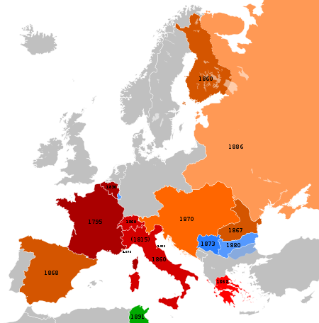
Français : Carte représentant les pays européens participants à l'Union Monétaire Latin entre 1866 et 1914
English: Map showing the European countries participating at the Latin Monetary Union between 1866 and 1914.
Deutsch: Übersicht der europäischen Teilnehmer an der Lateinischen Münzunion zwischen 1866 und 1914.
Die Helligkeit kennzeichnet das ungefähre Beitrittsdatum.
|
||||||||||||||||||||||||
| Data | (UTC) | ||||||||||||||||||||||||
| Fonte |
This file was derived from: |
||||||||||||||||||||||||
| Autor |
|
Lisensa
Esta fix es lisensada su la lisensa Attribution-Share Alike 3.0 Unported de Creative Commons.
- Tu es libre:
- per comparti – per copia, distribui e transmete la obra
- per remisca – per ajusta la obra
- Su la constrinjes seguente:
- atribui – Tu debe atribui la obra en la modo spesifada par la autor o lisensor (ma no en cualce modo cual sujesta ce el aproba tu o tua usa de la obra).
- share alike – Si tu altera, muta o developa plu esta obra, tu pote distribui la obra resultante sola su la mesma lisensa o un simil a esta.
Original upload log
This image is a derivative work of the following images:
- File:Blank_map_of_Europe_1890.svg licensed with Cc-by-sa-3.0
- 2012-02-21T02:42:58Z Alphathon 450x456 (444331 Bytes) == {{int:filedesc}} == {{Information |Description={{de|Politische Karte [[:de:Europa|Europas]] ca. 1890}} {{en|A blank map of Europe circa 1890 in SVG format.}} |Source={{Derived from|Europa_1890.jpg|Blank_map_of_Europe.svg|d
- File:Blank_map_of_Europe_1914.svg licensed with Cc-by-sa-3.0
- 2012-02-20T23:32:07Z Alphathon 450x456 (462678 Bytes) Fixed Romanian border (Bessarabia should have been Russian)
- 2011-10-31T00:06:48Z Alphathon 450x456 (458338 Bytes) == {{int:filedesc}} == {{Information |Description={{en|Blank map of Europe showing national borders as they stood in 1914.}} |Source=*[[:File:Blank_map_of_Europe.svg|]] |Date=2011-10-31 00:05 (UTC) |Author=*[[:File:Blank_map_
Uploaded with derivativeFX
Istoria de fix
Clica un data/ora per vide la fix en sua forma de alora.
| Data/Ora | Imajeta | Mesuras | Usor | Comenta | |
|---|---|---|---|---|---|
| aora | 12:29, 8 junio 2013 | | 450 × 456 (452 KB) | Sechsachtel | User created page with UploadWizard |
Usas de fix
La paje seguente lia a esta fix:
Usa global de fix
La otra vicis seguente usa esta fix:
- Usa en de.wikipedia.org
- Usa en en.wikipedia.org
- Usa en fr.wikipedia.org
- Usa en ht.wikipedia.org
- Usa en it.wikipedia.org
- Usa en ja.wikipedia.org
- Usa en pl.wikipedia.org
- Usa en ro.wikipedia.org
- Usa en uk.wikipedia.org
- Usa en www.wikidata.org