Fix:Levant (orthographic projection).png
Grandia de esta previde: 600 × 600 pixeles Otra densias: 240 × 240 pixeles | 480 × 480 pixeles | 768 × 768 pixeles | 1,024 × 1,024 pixeles | 2,000 × 2,000 pixeles.
Fix orijinal (2,000 × 2,000 pixeles, grandia de fix: 632 KB, tipo MIME: image/png)
Resoma
| Descrive |
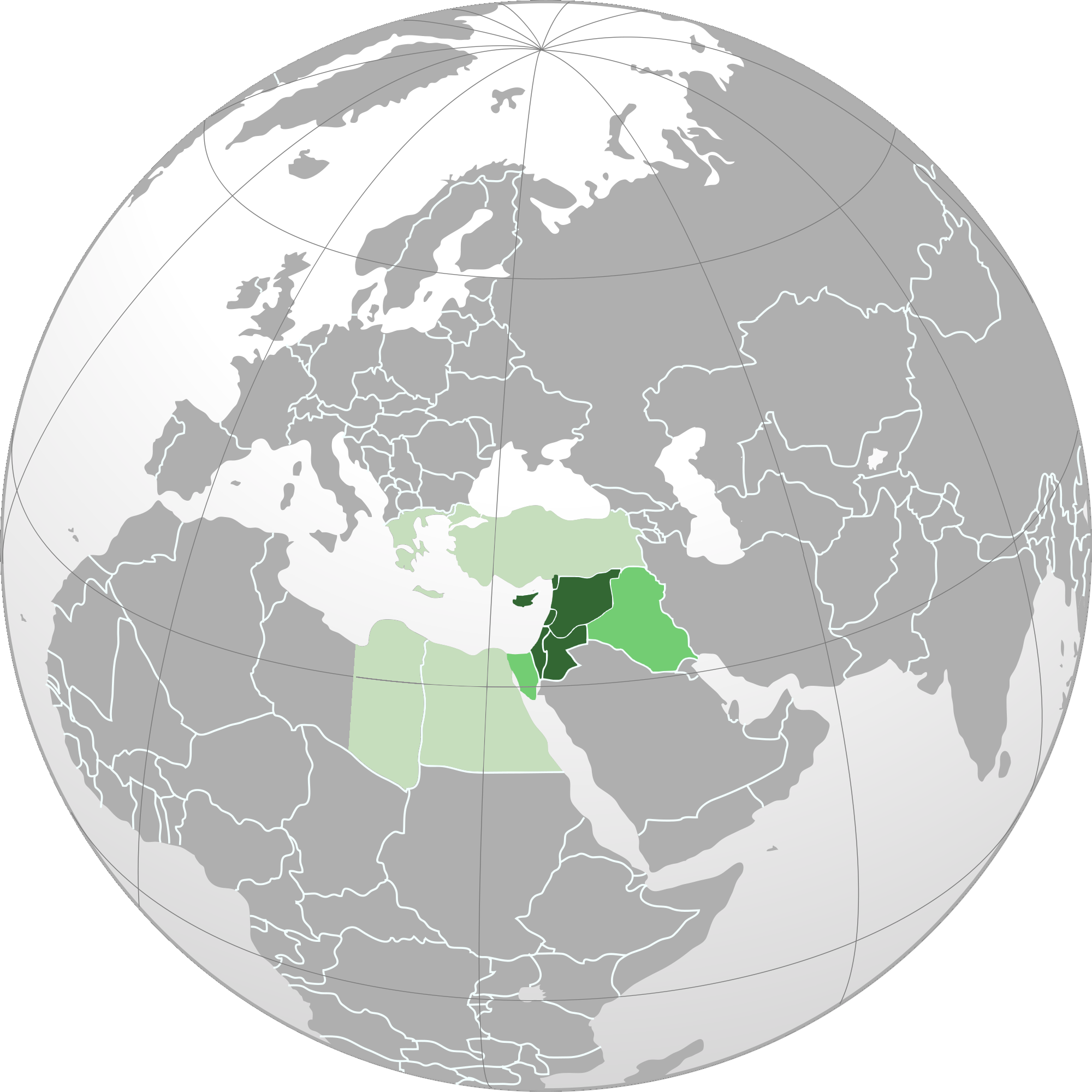
English: Orthographic map of Levant.
العربية: الخريطة الإرشادية لبلاد الشام.
اللون الأخضر الداكن: البلدان والمناطق الواقعة في منطقة المشرق العربي. (سوريا ولبنان وفلسطين والأردن وقبرص وهاتاي) اللون الأخضر المتوسط (بين الداكن والباهت): أراضي كاملة من البلدان التي يتم تضمين مناطقها في منطقة المشرق العربي. (العراق وسيناء) اللون الأخضر الباهت: البلدان والمناطق المدرجة أحيانًا في منطقة بلاد الشام. (اليونان وتركيا ومصر) |
| Data | |
| Fonte |
Obra propre Based on File:Norhern_Cyprus_(orthographic_projection).png by user:Seksen iki yüz kırk beş |
| Autor | Winkpolve |
.svg)
.svg)
.svg)
.svg)
.svg)
.svg)
.svg)
.svg)
.svg)
.svg)
.svg)
.svg)
.svg)
.svg)
.svg)
.svg)
.svg)
.svg)
.svg)
.svg)
.svg)
.svg)
.svg)
.svg)
.svg)
.svg)
.svg)
.svg)
.svg)
.svg)
.svg)
.svg)
.svg)
.svg)
.svg)
.svg)
.svg)
.svg)
.svg)
.svg)
.svg)
.svg)
.svg)
.svg)
.svg)
.svg)
.svg)
.svg)
.svg)
.svg)
.svg)
.svg)
.svg)
.svg)
.svg)
.svg)
.svg)
.svg)
.svg)
.svg)
.svg)
.svg)
.svg)
.svg)
.svg)
.svg)
.svg)
.svg)
.svg)
.svg)
.svg)
.svg)
.svg)
.svg)

.svg)

.svg)

.svg)
.svg)
.svg)
.svg)
.svg)
.svg)
.svg)


.svg)
.svg)
.svg)
.svg)
.svg)
.svg)
.svg)

.svg)
.svg)
.svg)
.svg)
.svg)
.svg)
.svg)
.svg)
.svg)

.svg)
.svg)
.svg)
.svg)
.svg)
.svg)
.svg)
_without_national_boundaries.svg)
.svg)
.svg)
.svg)
.svg)
.svg)
.svg)

.svg)
.svg)
.png)
.svg)
.svg)
.svg)
.svg)

.svg)
.svg)
.svg)
.svg)
.svg)
.svg)
.svg)
.svg)
.svg)
.svg)
.svg)

.svg)
.svg)
.svg)
.svg)
.svg)
.svg)
.svg)
.svg)
.svg)

.svg)
.svg)

.svg)
.svg)
.svg)
.svg)
.svg)
.svg)
.svg)
.svg)
.svg)
.svg)
.svg)
.svg)
.svg)
.svg)
.svg)
.svg)
.svg)
.svg)
.svg)
.svg)
.svg)
.svg)
.svg)
.svg)
.svg)
.svg)
.svg)
_-_Crimea_disputed.svg)
.svg)
.svg)
.svg)
.svg)
.svg)
.svg)
.svg)
.svg)
.svg)
.svg)
.svg)
_political.svg)
.svg)
.svg)
.svg)
.svg)
_-_Crimea_disputed_-_no_borders.svg)
.svg)
.svg)
.svg)
.svg)
.svg)
.svg)
.svg)
.svg)
.svg)
.svg)
.svg)

.svg)
.svg)
.svg)

.png)
.svg)
.svg)
.svg)
.svg)
.svg)
.svg)
.svg)
.svg)
.svg)
.svg)
.svg)
.svg)
.svg)
.svg)
.svg)
.svg)
.svg)
.svg)
.svg)
.svg)
.svg)
.svg)
.svg)
.svg)
.svg)
.svg)
.svg)
.svg)
.svg)
.svg)
.svg)
.svg)
.svg)
.svg)
.png)
.svg)
.svg)
.svg)
_(orthographic_projection).png)
.png)
.png)
| Orthographic projections maps created by Ssolbergj |
|---|
| Orthographic projections maps created by Ssolbergj: |
.svg)
.svg)
Lisensa
I, the copyright holder of this work, hereby publish it under the following license:
Esta fix es lisensada su la lisensa Attribution-Share Alike 3.0 Unported de Creative Commons.
- Tu es libre:
- per comparti – per copia, distribui e transmete la obra
- per remisca – per ajusta la obra
- Su la constrinjes seguente:
- atribui – Tu debe atribui la obra en la modo spesifada par la autor o lisensor (ma no en cualce modo cual sujesta ce el aproba tu o tua usa de la obra).
- share alike – Si tu altera, muta o developa plu esta obra, tu pote distribui la obra resultante sola su la mesma lisensa o un simil a esta.
Istoria de fix
Clica un data/ora per vide la fix en sua forma de alora.
| Data/Ora | Imajeta | Mesuras | Usor | Comenta | |
|---|---|---|---|---|---|
| aora | 00:18, 18 maio 2015 | | 2,000 × 2,000 (632 KB) | HD86 | changed boundaries of the Levant based on the sources cited in the article. |
| 18:33, 28 otobre 2013 |  | 2,000 × 2,000 (679 KB) | Hohum | Remove confusing Cyprus insert | |
| 05:40, 26 setembre 2012 |  | 2,000 × 2,000 (587 KB) | Mttll | Colored East Thrace of Turkey as national territory. | |
| 02:20, 28 agosto 2012 |  | 2,000 × 2,000 (447 KB) | Winkpolve | User created page with UploadWizard |
Usas de fix
La paje seguente lia a esta fix:
Usa global de fix
La otra vicis seguente usa esta fix:
- Usa en af.wikipedia.org
- Usa en ar.wikipedia.org
- Usa en ar.wiktionary.org
- Usa en azb.wikipedia.org
- Usa en bn.wikipedia.org
- Usa en ca.wikipedia.org
- Usa en de.wikipedia.org
- Usa en en.wikipedia.org
- Usa en en.wikibooks.org
- Usa en en.wikivoyage.org
- Usa en es.wikipedia.org
- Usa en et.wikipedia.org
- Usa en fa.wikipedia.org
- Usa en ga.wikipedia.org
- Usa en gl.wikipedia.org
- Usa en he.wikipedia.org
- Usa en he.wikivoyage.org
- Usa en hi.wikipedia.org
- Usa en id.wikipedia.org
- Usa en incubator.wikimedia.org
- Usa en ja.wikipedia.org
- Usa en kk.wikipedia.org
- Usa en ko.wikipedia.org
- Usa en ku.wikipedia.org
- Usa en ml.wikipedia.org
- Usa en ms.wikipedia.org
- Usa en pa.wikipedia.org
- Usa en pl.wikipedia.org
- Dyskusja:Operacja Entebbe
- Dyskusja:Limor Liwnat
- Dyskusja:Pokój z Aleppo
- Dyskusja:Amir Perec
- Dyskusja:Awigdor Lieberman
- Dyskusja:Mordechaj Nurok
- Dyskusja:Me’ir Porusz
- Dyskusja:Ze’ew Elkin
- Dyskusja:Icchak Szamir
- Dyskusja:Binjamin Netanjahu
- Wikiprojekt:Tygodnie tematyczne/Tydzień Artykułu Lewantyńskiego
- Dyskusja:Ranunculus chius
- Dyskusja:Ranunculus constantinopolitanus
- Dyskusja:Ranunculus cornutus
- Dyskusja:Uri Orbach
- Dyskusja:Trzydziesty trzeci rząd Izraela
Mostra plu usas global de esta fix.
.png)
.png)