Fix:Map of the Federated States of Micronesia CIA.jpg

Grandia de esta previde: 740 × 599 pixeles Otra densias: 296 × 240 pixeles | 593 × 480 pixeles | 948 × 768 pixeles | 1,200 × 972 pixeles.
Fix orijinal (1,200 × 972 pixeles, grandia de fix: 312 KB, tipo MIME: image/jpeg)
Resoma
| Descrive |
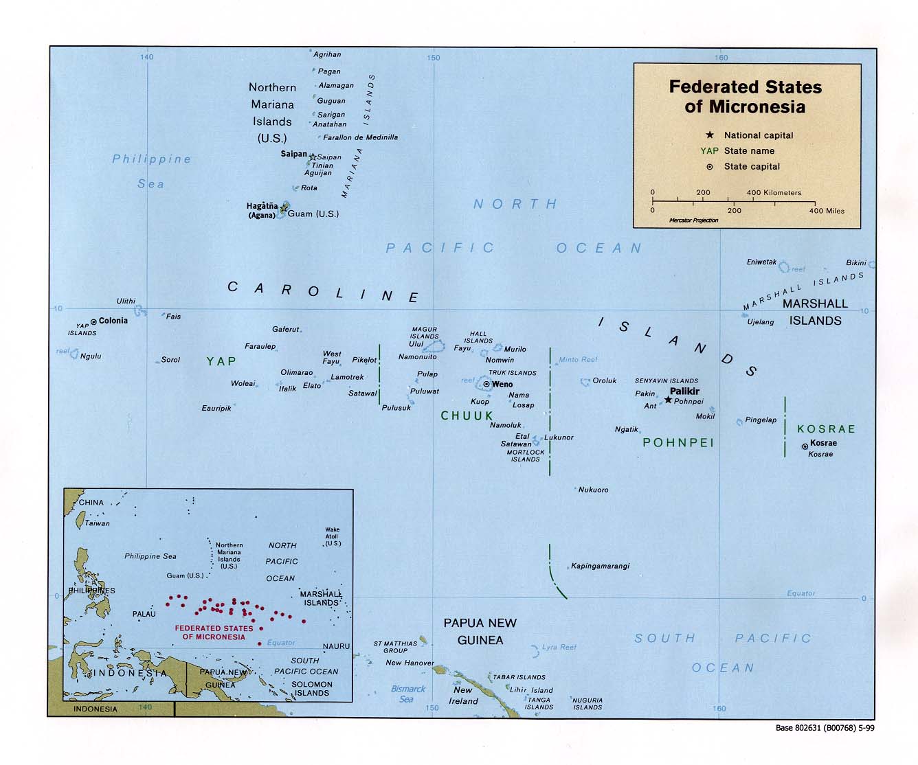
English: Map of the Federated States of Micronesia — in the Micronesia regon. |
| Data | |
| Fonte | Federated States of Micronesia (Political) 1999 from Perry-Castañeda Library Map Collection: Federated States of Micronesia Maps |
| Autor | U.S. Central Intelligence Agency |
| Permete (Reusante esta fix) |
Public domain |
Lisensa
| This image is a work of a Central Intelligence Agency employee, taken or made as part of that person's official duties. As a Work of the United States Government, this image or media is in the public domain in the United States.
|

|
Istoria de fix
Clica un data/ora per vide la fix en sua forma de alora.
| Data/Ora | Imajeta | Mesuras | Usor | Comenta | |
|---|---|---|---|---|---|
| aora | 15:57, 17 setembre 2010 | | 1,200 × 972 (312 KB) | Ras67 | rotated 0.22 degree ccw, cropped |
| 09:09, 22 janero 2005 |  | 1,336 × 1,114 (140 KB) | Hoshie | CIA map of FSM. {{PD-PCL|http://www.lib.utexas.edu/maps/islands_oceans_poles/micronesia_pol99.jpg}} |
Usas de fix
La paje seguente lia a esta fix:
Usa global de fix
La otra vicis seguente usa esta fix:
- Usa en af.wikipedia.org
- Usa en ami.wikipedia.org
- Usa en an.wikipedia.org
- Usa en ar.wikipedia.org
- Usa en ary.wikipedia.org
- Usa en avk.wikipedia.org
- Usa en az.wikipedia.org
- Usa en bg.wikipedia.org
- Usa en bn.wikipedia.org
- Usa en ca.wikipedia.org
- Usa en cs.wikipedia.org
- Usa en cv.wikipedia.org
- Usa en da.wikipedia.org
- Usa en de.wikipedia.org
- Usa en el.wikipedia.org
- Usa en en.wikipedia.org
- Federated States of Micronesia
- History of the Federated States of Micronesia
- Geography of the Federated States of Micronesia
- Ecclesiastical provinces and dioceses of the Episcopal Church
- User:Jonny-mt/Gallery of current first-level administrative country subdivisions maps
- Outline of the Federated States of Micronesia
- Index of Federated States of Micronesia–related articles
- Isokelekel
- List of islands of the Federated States of Micronesia
- Naval Base Ulithi
- US Naval Base Carolines
- 2023 Micronesian constitutional referendum
- Usa en eo.wikipedia.org
- Usa en es.wikipedia.org
- Usa en eu.wikipedia.org
- Usa en fa.wikipedia.org
- Usa en fi.wikipedia.org
- Usa en fr.wikipedia.org
Mostra plu usas global de esta fix.