Fix:Missouri River basin map.png

Grandia de esta previde: 800 × 575 pixeles Otra densias: 320 × 230 pixeles | 640 × 460 pixeles | 1,024 × 736 pixeles | 1,280 × 920 pixeles | 1,496 × 1,075 pixeles.
Fix orijinal (1,496 × 1,075 pixeles, grandia de fix: 2.63 MB, tipo MIME: image/png)
Resoma
| Descrive |
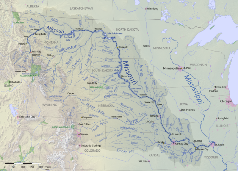
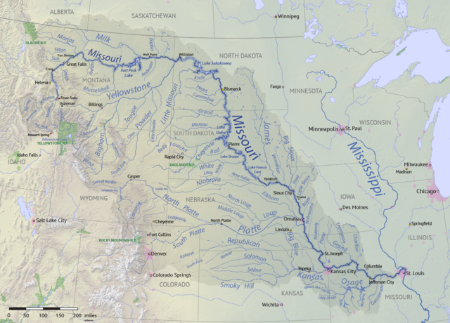
English: Map of the Missouri River drainage basin in the US and Canada. made using USGS and Natural Earth data. Replacement for File:Missouririvermap.jpg. |
| Data | |
| Fonte | Obra propre |
| Autor | Shannon1 |
.png)
Lisensa
I, the copyright holder of this work, hereby publish it under the following licenses:

|
Permete es donada per copia, distribui e/o altera esta documento su la restrinjes de la GNU Free Documentation License, Varia 1.2 o cualce varia plu tarda publicida par la Free Software Foundation, sin partes nonvariante, sin testo de covrente fronte e sin testo de covrente retro. Un copia de la lisensa es incluida en la parte nomida GNU Free Documentation License. |
This file is licensed under the Creative Commons Attribution-Share Alike 4.0 International, 3.0 Unported, 2.5 Generic, 2.0 Generic and 1.0 Generic license.
- Tu es libre:
- per comparti – per copia, distribui e transmete la obra
- per remisca – per ajusta la obra
- Su la constrinjes seguente:
- atribui – Tu debe atribui la obra en la modo spesifada par la autor o lisensor (ma no en cualce modo cual sujesta ce el aproba tu o tua usa de la obra).
- share alike – Si tu altera, muta o developa plu esta obra, tu pote distribui la obra resultante sola su la mesma lisensa o un simil a esta.
Tu pote eleje la lisensa cual tu prefere
Istoria de fix
Clica un data/ora per vide la fix en sua forma de alora.
| Data/Ora | Imajeta | Mesuras | Usor | Comenta | |
|---|---|---|---|---|---|
| aora | 00:15, 9 april 2018 | | 1,496 × 1,075 (2.63 MB) | Shannon1 | missing label |
| 21:56, 30 marto 2018 |  | 1,500 × 1,080 (2.8 MB) | Shannon1 | slight fixes | |
| 19:30, 30 marto 2018 |  | 1,500 × 1,078 (2.78 MB) | Shannon1 | {{Information |description ={{en|1=Map of the Missouri River drainage basin in the US and Canada. made using USGS and Natural Earth data. Replacement for File:Missouririvermap.jpg.}} |source =Own work |author =Shannon1 |date =2018-03-21 }} Category:Missouri River |
Usas de fix
La paje seguente lia a esta fix:
Usa global de fix
La otra vicis seguente usa esta fix:
- Usa en af.wikipedia.org
- Usa en azb.wikipedia.org
- Usa en az.wiktionary.org
- Usa en ba.wikipedia.org
- Usa en be.wikipedia.org
- Usa en bh.wikipedia.org
- Usa en bn.wikipedia.org
- Usa en ca.wikipedia.org
- Usa en cv.wikipedia.org
- Usa en da.wikipedia.org
- Usa en en.wikipedia.org
- Missouri River
- Grand River (South Dakota)
- User:Shannon1/Sandbox 5
- User:Shannon1/Maps
- Yellowstone expedition
- List of longest rivers of the United States (by main stem)
- List of tributaries of the Missouri River
- Wikipedia:Graphics Lab/Map workshop/Archive/Jul 2011
- List of dams in the Missouri River watershed
- User:Shannon1/Maps/to-do
- Joseph LaBarge
- Spread Eagle (steamboat)
- Emilie (steamboat)
- Usa en es.wikipedia.org
- Iowa
- Dakota del Norte
- Dakota del Sur
- Denver
- Río Misuri
- Bismarck (Dakota del Norte)
- Misuri
- Río Yellowstone
- Lincoln (Nebraska)
- Omaha (Nebraska)
- Columbia (Misuri)
- Kansas City (Misuri)
- Topeka
- Río Marías
- Kansas City (Kansas)
- Río Cheyenne
- Río Gallatin
- Great Falls (Montana)
- Río Platte
- Río Milk
- Río James (Dakotas)
- Río Smoky Hill
- Río Saline (Kansas)
- Río Niobrara
Mostra plu usas global de esta fix.