Fix:Narva basin map.svg

Grandia de esta previde PNG de esta fix SVG: 423 × 599 pixeles. Otra densias: 169 × 240 pixeles | 339 × 480 pixeles | 542 × 768 pixeles | 722 × 1,024 pixeles | 1,445 × 2,048 pixeles | 743 × 1,053 pixeles.
Fix orijinal (fix svg, densia: 743 × 1,053 pixeles, grandia: 2.46 MB)
Resoma
| Descrive |
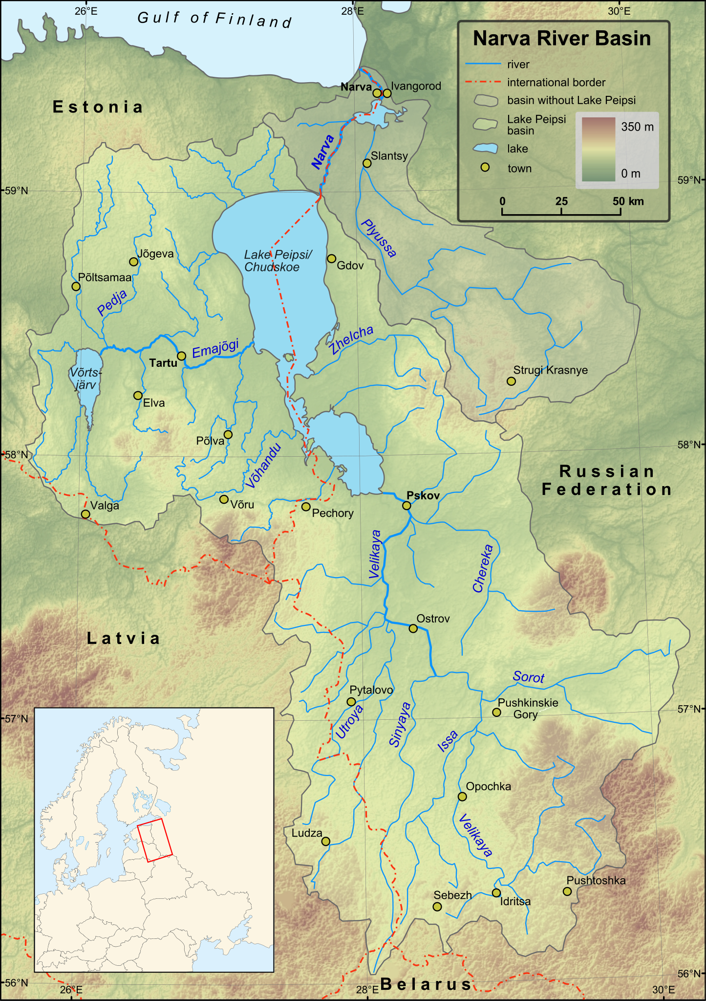
English: Map of Narva River and Lake Peipsi basins. Towns with population over 4000 (according to relevant Wikipedia lists) are included on the map. Terrain: embedded JPG. Projection: UTM Zone 35N |
| Data | |
| Fonte |
Created in ESRI ArcMap and Inkscape using a map from [1] and some other maps for corrections.
Elevation data from Shuttle Radar Topography Mission. |
| Autor | Hannu |
| Other versions | Magyar |
Lisensa
| I, the copyright holder of this work, release this work into the public domain. This applies worldwide. In some countries this may not be legally possible; if so: I grant anyone the right to use this work for any purpose, without any conditions, unless such conditions are required by law. |
Istoria de fix
Clica un data/ora per vide la fix en sua forma de alora.
| Data/Ora | Imajeta | Mesuras | Usor | Comenta | |
|---|---|---|---|---|---|
| aora | 16:43, 1 desembre 2009 | | 743 × 1,053 (2.46 MB) | Hannu~commonswiki | minor updates |
| 00:53, 28 novembre 2009 |  | 743 × 1,053 (2.44 MB) | Hannu~commonswiki | : | |
| 00:35, 28 novembre 2009 |  | 743 × 1,053 (2.44 MB) | Hannu~commonswiki | text to path | |
| 00:19, 28 novembre 2009 |  | 743 × 1,053 (2.06 MB) | Hannu~commonswiki | : | |
| 00:14, 28 novembre 2009 |  | 743 × 1,053 (2.05 MB) | Hannu~commonswiki | new map | |
| 18:53, 14 april 2009 |  | 738 × 1,004 (959 KB) | Hannu~commonswiki | vector location map | |
| 15:28, 17 janero 2009 |  | 738 × 1,004 (957 KB) | Hannu~commonswiki | {{Information |Description={{en|1=Map of Narva River and Lake Peipsi basins.}} |Source=Created in Inkscape using a map from [http://www.ilec.or.jp/eg/lbmi/pdf/20_Lake_Peipsi_Chudskoe_27February2006.pdf]. Location ma | |
| 16:18, 16 janero 2009 |  | 738 × 1,004 (639 KB) | Hannu~commonswiki | {{Information |Description={{en|1=Map of Narva River and Lake Peipsi basins.}} |Source=Created in Inkscape using a map from [http://www.ilec.or.jp/eg/lbmi/pdf/20_Lake_Peipsi_Chudskoe_27February2006.pdf]. Minimap mad | |
| 16:11, 16 janero 2009 |  | 738 × 1,004 (529 KB) | Hannu~commonswiki | {{Information |Description={{en|1=Map of Narva River and Lake Peipsi basins.}} |Source=Created in Inkscape using a map from [http://www.ilec.or.jp/eg/lbmi/pdf/20_Lake_Peipsi_Chudskoe_27February2006.pdf]. Minimap mad |
Usas de fix
La paje seguente lia a esta fix:
Usa global de fix
La otra vicis seguente usa esta fix:
- Usa en af.wikipedia.org
- Usa en als.wikipedia.org
- Usa en ar.wikipedia.org
- Usa en ast.wikipedia.org
- Usa en azb.wikipedia.org
- Usa en be-tarask.wikipedia.org
- Usa en bg.wikipedia.org
- Usa en ca.wikipedia.org
- Usa en cs.wikipedia.org
- Usa en da.wikipedia.org
- Usa en de.wikipedia.org
- Usa en el.wikipedia.org
- Usa en en.wikipedia.org
- Usa en es.wikipedia.org
- Usa en fa.wikipedia.org
- Usa en fi.wikipedia.org
- Luokka:Narvanjoen vesistö
- Velikaja
- Pljussa
- Piusa jõgi
- Narvanjoen vesistöalue
- Luokka:Narvanjoen alue
- Narvanjoen alue
- Janja (Pljussa)
- Ljuta (Pljussa)
- Vjorduga
- Pljussan valuma-alue
- Kureja
- Pihkovanjoki
- Luokka:Velikajan valuma-alue
- Tšerjoha (joki)
- Haanjan ylänkö
- Alūksnen ylänkö
- Želtša
- Velikajan valuma-alue
- Peipsijärven valuma-alue
- Luokka:Peipsijärven valuma-alue
- Peipsijärven alue
- Luokka:Emajoen alue
- Luokka:Võrtsjärven valuma-alue
- Võhandu jõgi
- Emajoen valuma-alue
Mostra plu usas global de esta fix.