Fix:New Caledonia and Vanuatu bathymetric and topographic map-fr.jpg

Grandia de esta previde: 800 × 561 pixeles Otra densias: 320 × 224 pixeles | 640 × 449 pixeles | 1,024 × 718 pixeles | 1,280 × 898 pixeles | 2,560 × 1,795 pixeles | 2,980 × 2,090 pixeles.
Fix orijinal (2,980 × 2,090 pixeles, grandia de fix: 1.53 MB, tipo MIME: image/jpeg)
Resoma
| Descrive |
|
||
| Data | ; revision 2013-12 | ||
| Fonte |
Own work ;
|
||
| Autor | Eric Gaba (Sting - fr:Sting) | ||
| Permete (Reusante esta fix) |
|
||
| Other versions |
[]
Administrative and simplified version:
|


| Camera location | | View this and other nearby images on: OpenStreetMap |
|---|
Lisensa
I, the copyright holder of this work, hereby publish it under the following licenses:

|
Permete es donada per copia, distribui e/o altera esta documento su la restrinjes de la GNU Free Documentation License, Varia 1.2 o cualce varia plu tarda publicida par la Free Software Foundation, sin partes nonvariante, sin testo de covrente fronte e sin testo de covrente retro. Un copia de la lisensa es incluida en la parte nomida GNU Free Documentation License. |
This file is licensed under the Creative Commons Attribution-Share Alike 4.0 International, 3.0 Unported, 2.5 Generic, 2.0 Generic and 1.0 Generic license.
- Tu es libre:
- per comparti – per copia, distribui e transmete la obra
- per remisca – per ajusta la obra
- Su la constrinjes seguente:
- atribui – Tu debe atribui la obra en la modo spesifada par la autor o lisensor (ma no en cualce modo cual sujesta ce el aproba tu o tua usa de la obra).
- share alike – Si tu altera, muta o developa plu esta obra, tu pote distribui la obra resultante sola su la mesma lisensa o un simil a esta.
Tu pote eleje la lisensa cual tu prefere
Istoria de fix
Clica un data/ora per vide la fix en sua forma de alora.
| Data/Ora | Imajeta | Mesuras | Usor | Comenta | |
|---|---|---|---|---|---|
| aora | 17:40, 19 desembre 2013 | | 2,980 × 2,090 (1.53 MB) | Sting | Île de Sable removed (cf http://www.shom.fr/fileadmin/data-www/DMI/Communiques_de_presse/2012/COMMUNIQUE-DE-PRESSE-SANDY-ISLAND.doc) ; new elevation data used (SRTM30 Plus) |
| 11:38, 30 maio 2011 |  | 2,980 × 2,090 (1.46 MB) | Sting | Reverted to version as of 21:32, 16 July 2010 (sRGB profile) | |
| 20:40, 17 julio 2010 |  | 2,980 × 2,090 (1.35 MB) | Sting | Better unsaturated colors than over-saturated ones in non color managed browsers | |
| 21:32, 16 julio 2010 |  | 2,980 × 2,090 (1.46 MB) | Sting | Color profile correction | |
| 23:05, 29 junio 2010 |  | 2,980 × 2,090 (1.35 MB) | Sting | With sRGB color profile | |
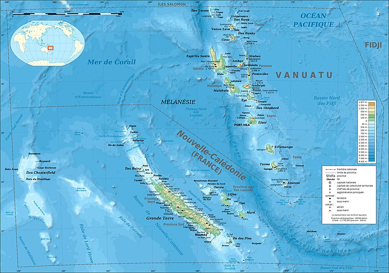
| 03:12, 17 febrero 2009 |  | 2,980 × 2,090 (1.39 MB) | Sting | == Summary == {{Location|18|30|00|S|166|00|00|E|scale:10000000}} <br/> {{Information |Description={{en|Bathymetric and topographic map of New Caledonia and Vanuatu, Oceania.}} {{fr|Carte bathymétrique |
Usas de fix
La paje seguente lia a esta fix:
Usa global de fix
La otra vicis seguente usa esta fix:
- Usa en avk.wikipedia.org
- Usa en azb.wikipedia.org
- Usa en bg.wikipedia.org
- Usa en bi.wikipedia.org
- Usa en bs.wikinews.org
- Usa en en.wikipedia.org
- Usa en eo.wikipedia.org
- Usa en es.wikipedia.org
- Usa en fi.wikipedia.org
- Usa en fr.wikipedia.org
- Vanuatu
- Liste des colonies françaises
- Christian Zuber
- Nouvelle-Calédonie
- Référendum en France
- Projet:Cartographie/Cartes standards/Pays
- 2010 par pays en Océanie
- 2011 par pays en Océanie
- Rallye de Nouvelle-Calédonie
- Français océanien
- Utilisateur:Exp JC/Brouillon
- Environnement en Nouvelle-Calédonie
- 2010 en Nouvelle-Calédonie
- 2011 au Vanuatu
- 2010 au Vanuatu
- Usa en fr.wikinews.org
- Usa en fr.wikiversity.org
- Usa en gcr.wikipedia.org
- Usa en gl.wikipedia.org
- Usa en he.wikipedia.org
- Usa en hu.wikipedia.org
- Usa en ky.wikipedia.org
- Usa en la.wikipedia.org
- Usa en nl.wikipedia.org
- Usa en nn.wikipedia.org
- Usa en oc.wikipedia.org
- Usa en pl.wikipedia.org
- Usa en pl.wikivoyage.org
- Usa en pt.wikipedia.org
Mostra plu usas global de esta fix.