Fix:Political map of the Low Countries (1350)-NL.svg

Grandia de esta previde PNG de esta fix SVG: 468 × 599 pixeles. Otra densias: 187 × 240 pixeles | 375 × 480 pixeles | 600 × 768 pixeles | 800 × 1,024 pixeles | 1,599 × 2,048 pixeles | 2,818 × 3,608 pixeles.
Fix orijinal (fix svg, densia: 2,818 × 3,608 pixeles, grandia: 886 KB)
Resoma
| Descrive |
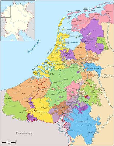
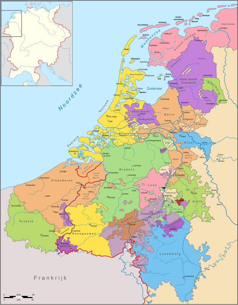
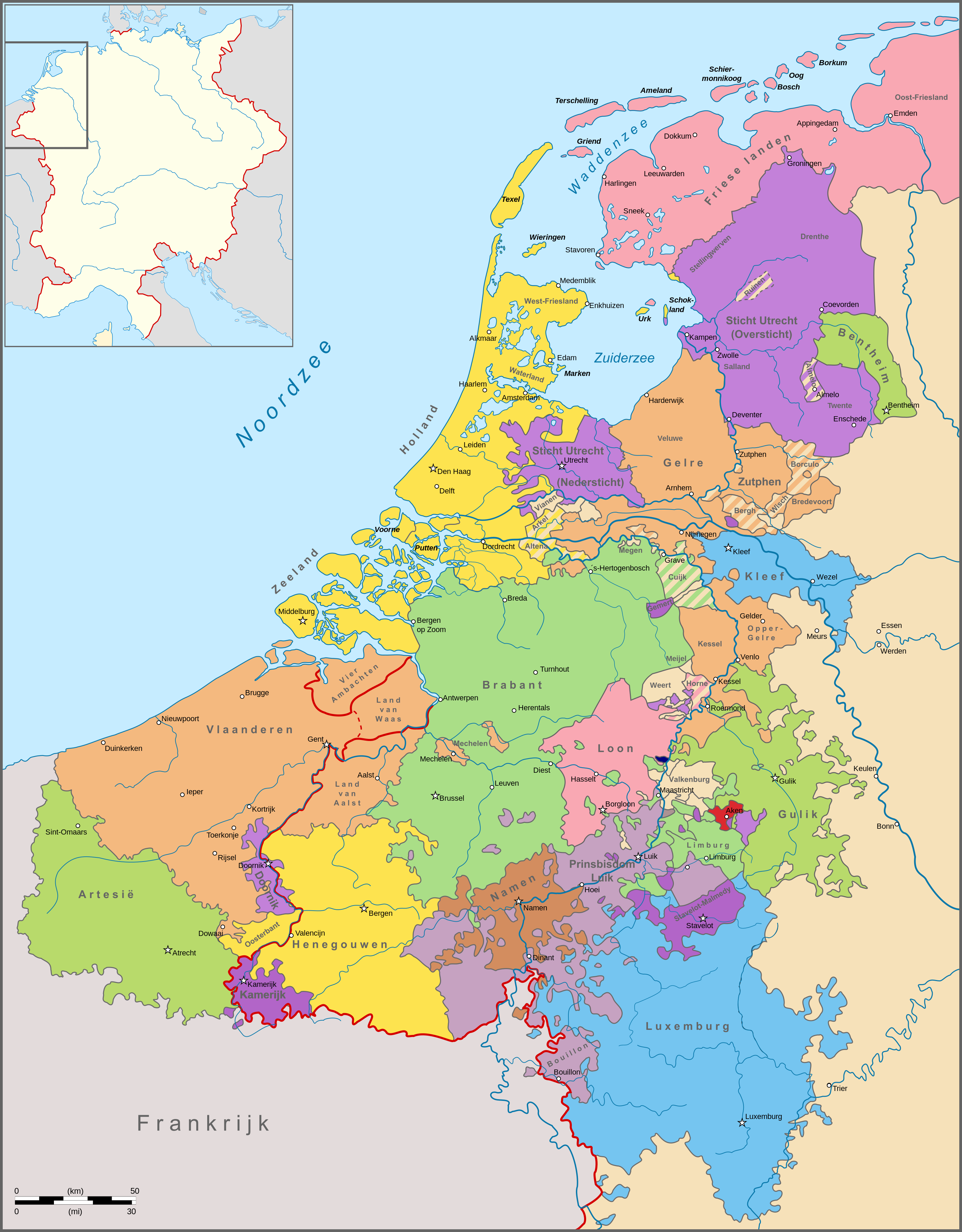
English: Map of the political situation in the Netherlands around 1350. Nederlands: Kaart van de politieke situatie in de Nederlanden omstreeks 1350. |
| Data | |
| Fonte | Obra propre |
| Autor | Sir Iain |
| Other versions |
cropped File:Political map of Limburg (1350)-NL.svg
|
-hu.svg)
-NL.svg)
-NL.svg)
Lisensa
I, the copyright holder of this work, hereby publish it under the following license:
Esta fix es lisensada su la lisensa Attribution-Share Alike 3.0 Unported de Creative Commons.
- Tu es libre:
- per comparti – per copia, distribui e transmete la obra
- per remisca – per ajusta la obra
- Su la constrinjes seguente:
- atribui – Tu debe atribui la obra en la modo spesifada par la autor o lisensor (ma no en cualce modo cual sujesta ce el aproba tu o tua usa de la obra).
- share alike – Si tu altera, muta o developa plu esta obra, tu pote distribui la obra resultante sola su la mesma lisensa o un simil a esta.
Istoria de fix
Clica un data/ora per vide la fix en sua forma de alora.
| Data/Ora | Imajeta | Mesuras | Usor | Comenta | |
|---|---|---|---|---|---|
| aora | 14:36, 15 novembre 2011 | | 2,818 × 3,608 (886 KB) | Sir Iain |
Usas de fix
La paje seguente lia a esta fix:
Usa global de fix
La otra vicis seguente usa esta fix:
- Usa en af.wikipedia.org
- Usa en ar.wikipedia.org
- Usa en be.wikipedia.org
- Usa en bg.wikipedia.org
- Usa en da.wikipedia.org
- Usa en en.wikipedia.org
- Usa en eo.wikipedia.org
- Usa en fr.wikipedia.org
- Usa en fy.wikipedia.org
- Usa en he.wikipedia.org
- Usa en id.wikipedia.org
- Usa en it.wikipedia.org
- Usa en ja.wikipedia.org
- Usa en ka.wikipedia.org
- Usa en lld.wikipedia.org
- Usa en lv.wikipedia.org
- Usa en mk.wikipedia.org
- Usa en nl.wikipedia.org
- 1350
- Landsheerlijkheid
- Landsheer
- Gewest (Lage Landen)
- Kamerijk en het Kamerijkse
- Geschiedenis van de Nederlanden in de Middeleeuwen
- Overleg:Geschiedenis van de Nederlanden in de Middeleeuwen
- Belgisch-Nederlandse betrekkingen
- Karel van Brimeu
- Overleg gebruiker:BoH/Archief 3
- Overleg gebruiker:Arch (hernoemd)/Archief/nov 2011
- Tijdlijn van de Lage Landen (steden en vorstendommen)
- Overleg gebruiker:Henk B./Archief/jul 2013
- Gebruiker:Sir Iain/Kaarten
- Geschiedenis van de opkomst van vorstendommen en steden in de Lage Landen
- Usa en nl.wiktionary.org
- Usa en no.wikipedia.org
- Usa en ro.wikipedia.org
- Usa en ru.wikipedia.org
Mostra plu usas global de esta fix.
-NL.svg)
-NL.svg)