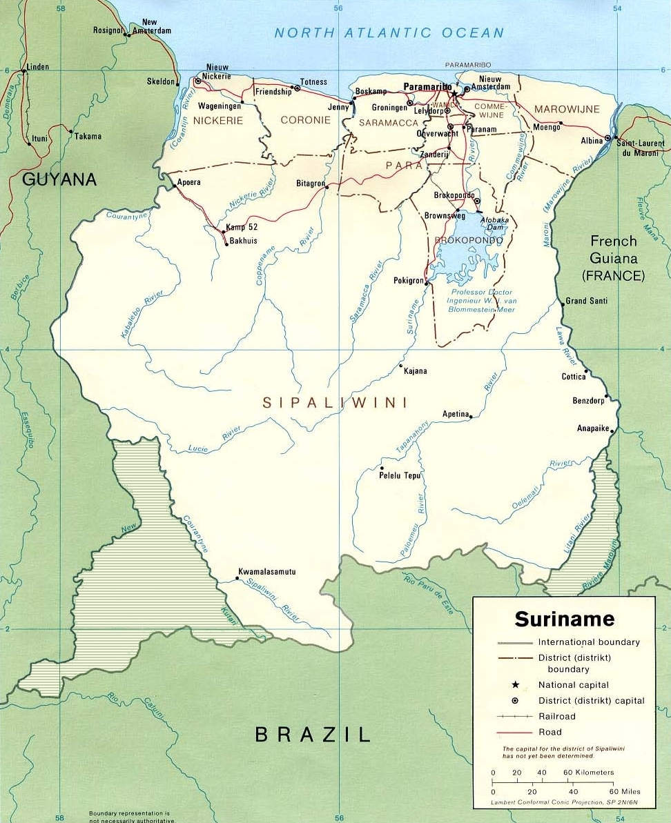
Fix:Suriname1991 Karte umstrittene Gebiete.jpg
Grandia de esta previde: 488 × 599 pixeles Otra densias: 195 × 240 pixeles | 391 × 480 pixeles | 972 × 1,193 pixeles.
Fix orijinal (972 × 1,193 pixeles, grandia de fix: 712 KB, tipo MIME: image/jpeg)
Land kaart
Resoma
| Descrive |
English: Edited CIA map of Suriname.
Deutsch: Überarbeitete CIA-Karte Suriname (einschließlich, in Grau der mit Guyana und Französisch-Guayana umstrittenen Gebiete)
Nederlands: CIA-kaart van Suriname uit 1991 met toegevoegde betwiste gebieden |
| Data | |
| Fonte | Originally from de.wikipedia; description page is/was here. |
| Autor | Original uploader was Benutzer:Brokopondo at de.wikipedia |
| Permete (Reusante esta fix) |
PD according to LoC. Edited by Benutzer:Brokopondo and released under PD. |
| Other versions | Derivative works of this file: Brokopondo Reservoir.png |
Lisensa
| This image is a work of a Central Intelligence Agency employee, taken or made as part of that person's official duties. As a Work of the United States Government, this image or media is in the public domain in the United States.
|

|
| This work has been released into the public domain by its author, Brokopondo at German Vicipedia. This applies worldwide. In some countries this may not be legally possible; if so: Brokopondo grants anyone the right to use this work for any purpose, without any conditions, unless such conditions are required by law. |
Original upload log
(All user names refer to de.wikipedia)
- 11:51, 14. Jun. 2006 (CEST) Benutzer:Brokopondo 1078×1300 (568 Kbytes) '
Istoria de fix
Clica un data/ora per vide la fix en sua forma de alora.
| Data/Ora | Imajeta | Mesuras | Usor | Comenta | |
|---|---|---|---|---|---|
| aora | 17:40, 12 otobre 2021 | | 972 × 1,193 (712 KB) | Lojwe | Cropped 10 % horizontally, 8 % vertically using CropTool with precise mode. |
| 16:43, 12 novembre 2007 |  | 1,078 × 1,300 (568 KB) | Hu Totya | ||
| 16:20, 12 novembre 2007 |  | 497 × 599 (49 KB) | Szajci | {{Information |Description=Karte Suriname |Source=Originally from [http://de.wikipedia.org de.wikipedia]; description page is/was [http://de.wikipedia.org/w/index.php?title=Bild:Suriname1991_Karte_umstrittene_Gebiete.jpg here]. |Date= |Author=Original upl |
Usas de fix
La paje seguente lia a esta fix:
Usa global de fix
La otra vicis seguente usa esta fix:
- Usa en af.wikipedia.org
- Usa en ar.wikipedia.org
- Usa en arz.wikipedia.org
- Usa en awa.wikipedia.org
- Usa en az.wikipedia.org
- Usa en ca.wikipedia.org
- Usa en ceb.wikipedia.org
- Usa en de.wikipedia.org
- Usa en el.wikipedia.org
- Usa en en.wikipedia.org
- Usa en eo.wikipedia.org
- Usa en es.wikipedia.org
- Usa en fa.wikipedia.org
- Usa en fi.wikipedia.org
- Usa en frr.wikipedia.org
- Usa en fr.wikipedia.org
- Usa en fy.wikipedia.org
- Usa en gd.wikipedia.org
Mostra plu usas global de esta fix.