Fix:Tajikistan Map TI-map.gif
No densia plu alta es disponable.
Tajikistan_Map_TI-map.gif (636 × 325 pixeles, grandia de fix: 29 KB, tipo MIME: image/gif)
Resoma
| Descrive |
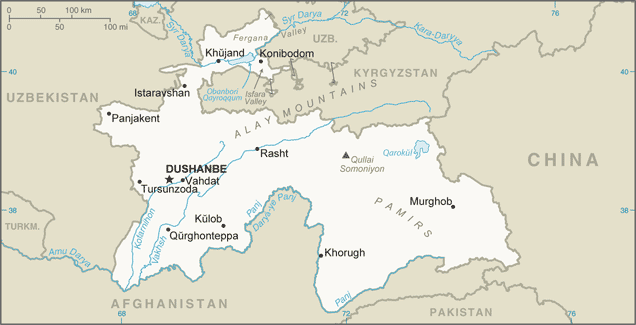
English: Tajikistan Map (This version of the map includes significant changes from the previous version of the map including changes to the China-Tajikistan border.) |
| Data | 2010s |
| Fonte | [1] |
| Autor | CIA Factbook |
| Other versions |
|

![[1]](https://www.cia.gov/library/publications/the-world-factbook/attachments/maps/TI-map.gif)
Lisensa
This work is in the public domain in the United States because it is a work prepared by an officer or employee of the United States Government as part of that person’s official duties under the terms of Title 17, Chapter 1, Section 105 of the US Code.
Note: This only applies to original works of the Federal Government and not to the work of any individual U.S. state, territory, commonwealth, county, municipality, or any other subdivision. This template also does not apply to postage stamp designs published by the United States Postal Service since 1978. (See § 313.6(C)(1) of Compendium of U.S. Copyright Office Practices). It also does not apply to certain US coins; see The US Mint Terms of Use.
|
 | |
| This file has been identified as being free of known restrictions under copyright law, including all related and neighboring rights. | ||
Istoria de fix
Clica un data/ora per vide la fix en sua forma de alora.
| Data/Ora | Imajeta | Mesuras | Usor | Comenta | |
|---|---|---|---|---|---|
| aora | 00:49, 21 janero 2020 | | 636 × 325 (29 KB) | Geographyinitiative | User created page with UploadWizard |
Usas de fix
La paje seguente lia a esta fix:
Usa global de fix
La otra vicis seguente usa esta fix:
- Usa en ar.wikipedia.org
- Usa en ast.wikipedia.org
- Usa en bg.wiktionary.org
- Usa en bn.wikipedia.org
- Usa en ca.wikipedia.org
- Usa en cs.wikipedia.org
- Usa en dsb.wikipedia.org
- Usa en el.wikipedia.org
- Usa en en.wikipedia.org
- Usa en en.wiktionary.org
- Usa en eo.wikinews.org
- Usa en es.wikipedia.org
- Usa en eu.wikipedia.org
- Usa en fa.wikipedia.org
- Usa en fr.wikipedia.org
- Usa en gd.wikipedia.org
- Usa en gl.wikipedia.org
- Usa en ha.wikipedia.org
- Usa en hif.wikipedia.org
- Usa en hr.wikipedia.org
- Usa en id.wikipedia.org
- Usa en is.wikipedia.org
- Usa en it.wikipedia.org
Mostra plu usas global de esta fix.