Fix:Thrace and present-day state borderlines.png

Grandia de esta previde: 501 × 600 pixeles Otra densias: 200 × 240 pixeles | 593 × 710 pixeles.
Fix orijinal (593 × 710 pixeles, grandia de fix: 142 KB, tipo MIME: image/png)
Resoma
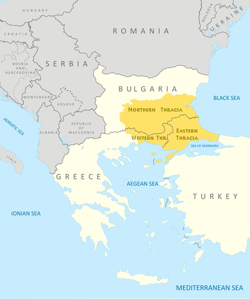
| Description |
English: Thrace and present-day state borderlines
Български: Тракия и съвременните държавни граници |
|||||||||
| Data | ||||||||||
| Fonte | File:Thrace modern state boundaries.png | |||||||||
| Creor | ||||||||||
| Geotemporal data | ||||||||||
| Bounding box |
|
|||||||||
| Georeferencing | ||||||||||
| Other versions | File:Thrace modern state boundaries.png, File:Thrace and present-day state borderlines zh.png, File:Thrace and present-day state borderlines-ar.png | |||||||||
Lisensa
I, the copyright holder of this work, hereby publish it under the following licenses:
Esta fix es lisensada su la lisensa Attribution-Share Alike 3.0 Unported de Creative Commons.
- Tu es libre:
- per comparti – per copia, distribui e transmete la obra
- per remisca – per ajusta la obra
- Su la constrinjes seguente:
- atribui – Tu debe atribui la obra en la modo spesifada par la autor o lisensor (ma no en cualce modo cual sujesta ce el aproba tu o tua usa de la obra).
- share alike – Si tu altera, muta o developa plu esta obra, tu pote distribui la obra resultante sola su la mesma lisensa o un simil a esta.

|
Permete es donada per copia, distribui e/o altera esta documento su la restrinjes de la GNU Free Documentation License, Varia 1.2 o cualce varia plu tarda publicida par la Free Software Foundation, sin partes nonvariante, sin testo de covrente fronte e sin testo de covrente retro. Un copia de la lisensa es incluida en la parte nomida GNU Free Documentation License. |
Tu pote eleje la lisensa cual tu prefere

|
This map image could be re-created using vector graphics as an SVG file. This has several advantages; see Commons:Media for cleanup for more information. If an SVG form of this image is available, please upload it and afterwards replace this template with
{{vector version available|new image name}}.
It is recommended to name the SVG file “Thrace and present-day state borderlines.svg”—then the template Vector version available (or Vva) does not need the new image name parameter. |
Istoria de fix
Clica un data/ora per vide la fix en sua forma de alora.
| Data/Ora | Imajeta | Mesuras | Usor | Comenta | |
|---|---|---|---|---|---|
| aora | 09:17, 6 otobre 2017 | | 593 × 710 (142 KB) | Mélomène | Details |
| 09:57, 24 otobre 2009 |  | 593 × 710 (145 KB) | Пакко | again | |
| 09:56, 24 otobre 2009 |  | 600 × 710 (154 KB) | Пакко | some changes | |
| 09:55, 24 otobre 2009 |  | 3,292 × 3,897 (1.06 MB) | Пакко | SOME CHANGEIS | |
| 19:20, 16 agosto 2009 |  | 583 × 800 (157 KB) | Пакко | some changes | |
| 13:02, 15 agosto 2009 |  | 3,074 × 3,750 (954 KB) | Пакко | {{Information |Description={{en|1=Thrace and present-day state borderlines}} {{bg|1=Тракия и съвременните държавни граници}} |Source=File:Thrace modern state boundaries.png |Author=Пакко |Dat |
Usas de fix
La paje seguente lia a esta fix:
Usa global de fix
La otra vicis seguente usa esta fix:
- Usa en af.wikipedia.org
- Usa en am.wikipedia.org
- Usa en ast.wikipedia.org
- Usa en azb.wikipedia.org
- Usa en ba.wikipedia.org
- Usa en bg.wikipedia.org
- Usa en bn.wikipedia.org
- Usa en br.wikipedia.org
- Usa en bs.wikipedia.org
- Usa en bs.wiktionary.org
- Usa en ca.wikipedia.org
- Usa en ckb.wikipedia.org
- Usa en crh.wikipedia.org
- Usa en cs.wikipedia.org
- Usa en cs.wiktionary.org
- Usa en da.wikipedia.org
- Usa en de.wikipedia.org
- Usa en de.wikivoyage.org
- Usa en el.wikipedia.org
- Usa en en.wikipedia.org
- Usa en en.wikiversity.org
- Usa en en.wikivoyage.org
- Usa en en.wiktionary.org
- Usa en eo.wikipedia.org
- Usa en es.wikipedia.org
- Usa en et.wikipedia.org
- Usa en eu.wikipedia.org
- Usa en fa.wikipedia.org
- Usa en fi.wikipedia.org
- Usa en fr.wikipedia.org
- Usa en fr.wiktionary.org
- Usa en ga.wikipedia.org
- Usa en gl.wikipedia.org
- Usa en hi.wikipedia.org
- Usa en hr.wikipedia.org
- Usa en hr.wiktionary.org
- Usa en hy.wikipedia.org
- Usa en hyw.wikipedia.org
- Usa en ia.wikipedia.org
Mostra plu usas global de esta fix.