Viking_expansion.png(507 × 310 pixeles, grandia de fix: 109 KB, tipo MIME: image/png)

Esta fix veni de Wikimedia Commons e es cisa usada par otra projetas. La descrive en sua paje de descrive de fix ala es mostrada a su.

(see en:File talk:Viking Expansion.svg)

Resoma

Descrive
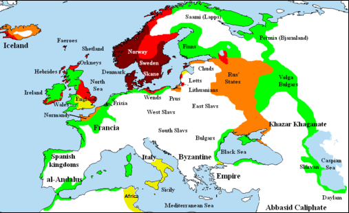
English: Map showing area of Scandinavian settlement (Vikings and Normans descendants from Normandy) in
 
eighth century
 
ninth century
 
tenth century
 
eleventh century
 
denotes areas subjected to frequent Scandinavian contacts, but with little or no Scandinavian settlement
Data 14 novembre 2006 (original upload date)
Fonte Briangotts (original uploader)
Autor Briangotts (original uploader)
Permete
(Reusante esta fix)
I, the copyright holder of this work, hereby publish it under the following licenses:
GNU head Permete es donada per copia, distribui e/o altera esta documento su la restrinjes de la GNU Free Documentation License, Varia 1.2 o cualce varia plu tarda publicida par la Free Software Foundation, sin partes nonvariante, sin testo de covrente fronte e sin testo de covrente retro. Un copia de la lisensa es incluida en la parte nomida GNU Free Documentation License.
w:en:Creative Commons
atribui share alike
Esta fix es lisensada su la lisensa Attribution-Share Alike 3.0 Unported de Creative Commons.
Tu es libre:
  • per comparti – per copia, distribui e transmete la obra
  • per remisca – per ajusta la obra
Su la constrinjes seguente:
  • atribui – Tu debe atribui la obra en la modo spesifada par la autor o lisensor (ma no en cualce modo cual sujesta ce el aproba tu o tua usa de la obra).
  • share alike – Si tu altera, muta o developa plu esta obra, tu pote distribui la obra resultante sola su la mesma lisensa o un simil a esta.
This licensing tag was added to this file as part of the GFDL licensing update.
Tu pote eleje la lisensa cual tu prefere
Other versions

[edita]

File:Viking Expansion.svg is a vector version of this file. It should be used in place of this PNG file when not inferior.

File:Viking expansion.png → File:Viking Expansion.svg

For more information, see Help:SVG.

In other languages
Alemannisch  Bahasa Indonesia  Bahasa Melayu  British English  català  čeština  dansk  Deutsch  eesti  English  español  Esperanto  euskara  français  Frysk  galego  hrvatski  Ido  italiano  lietuvių  magyar  Nederlands  norsk bokmål  norsk nynorsk  occitan  Plattdüütsch  polski  português  português do Brasil  română  Scots  sicilianu  slovenčina  slovenščina  suomi  svenska  Tiếng Việt  Türkçe  vèneto  Ελληνικά  беларуская (тарашкевіца)  български  македонски  нохчийн  русский  српски / srpski  татарча/tatarça  українська  ქართული  հայերեն  বাংলা  தமிழ்  മലയാളം  ไทย  한국어  日本語  简体中文  繁體中文  עברית  العربية  فارسی  +/−
New SVG image

Captions

Add a one-line explanation of what this file represents

Items portrayed in this file

depicts English

copyrighted English

inception English

14 novembre 2006

media type English

image/png

Istoria de fix

Clica un data/ora per vide la fix en sua forma de alora.

(la plu novas | la plu veas) Regarda (10 plu resentes | ) (10 | 20 | 50 | 100 | 250 | 500)
Data/OraImajetaMesurasUsorComenta
aora22:58, 25 febrero 2018Imajeta per revisa de 22:58, 25 febrero 2018507 × 310 (109 KB)AsmodimAdded the territory of the Norman "Kingdom of Africa (see the wikipedia article), conquests of the Norman kingdom of Sicily under Roger II
18:10, 5 agosto 2016Imajeta per revisa de 18:10, 5 agosto 2016507 × 310 (109 KB)TheutatisExpanded area in Italy according to Norman expansion.
10:52, 17 julio 2008Imajeta per revisa de 10:52, 17 julio 2008800 × 310 (140 KB)F7~commonswiki
21:14, 15 maio 2007Imajeta per revisa de 21:14, 15 maio 20071,464 × 568 (51 KB)Briangotts== Summary == {{Information |Description= Map showing area of Scandinavian settlement in<br> {{legend|#800000|eighth centuries}} {{legend|#f00|ninth centuries}} {{legend|#ff8000|tenth centuries}} {{legend|#eded00|eleventh centuries}} {{legend|#0f0|denotes
13:58, 10 maio 2007Imajeta per revisa de 13:58, 10 maio 20071,464 × 568 (51 KB)Briangotts== Summary == {{Information |Description= Map showing area of Scandinavian settlement in<br> {{legend|#800000|eighth century}} {{legend|#f00|ninth century}} {{legend|#ff8000|tenth century}} {{legend|#eded00|eleventh century}} {{legend|#0f0|denotes areas s
19:56, 16 april 2007Imajeta per revisa de 19:56, 16 april 20071,464 × 568 (33 KB)Tene~commonswikiOptimised (0)
11:43, 23 febrero 2007Imajeta per revisa de 11:43, 23 febrero 20071,464 × 568 (79 KB)Dbachmann"yellow"
11:33, 23 febrero 2007Imajeta per revisa de 11:33, 23 febrero 20071,464 × 568 (80 KB)Dbachmanncropped, fiddled with Iceland.
18:58, 2 febrero 2007Imajeta per revisa de 18:58, 2 febrero 20071,838 × 710 (62 KB)Tene~commonswikiOptimised (0)
12:50, 20 janero 2007Imajeta per revisa de 12:50, 20 janero 20071,838 × 710 (110 KB)Liftarn{{Information |Description=Map showing area of Scandinavian settlement in the eighth (dark red), ninth (red), tenth (orange) and eleventh (yellow) centuries. Green denotes areas subjected to frequent en:Viking raids. [[:e
(la plu novas | la plu veas) Regarda (10 plu resentes | ) (10 | 20 | 50 | 100 | 250 | 500)

No pajes lia a esta fix.

Usa global de fix

La otra vicis seguente usa esta fix:

Metadatos