Fix:Yangtze River Map.png
No densia plu alta es disponable.
Yangtze_River_Map.png (576 × 355 pixeles, grandia de fix: 123 KB, tipo MIME: image/png)
Resoma
| Descrive |
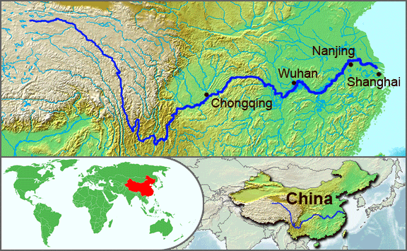
English: The underlying topographic maps used in this image come from the Demis Web Map Server, and are in the public domain. The world locator map is derived from :Image:BlankMap-World.png. I added the feature layers myself. —Papayoung ☯ 20:57, 1 October 2005 (UTC) |
| Data | 1 otobre 2005 (original upload date) |
| Fonte | Transferred from en.wikipedia to Commons by Common Good using CommonsHelper. |
| Autor | The original uploader was Papayoung at English Vicipedia. |
| Other versions |
|
.JPG)
Lisensa
| Esta fix es lisensada su la lisensa de Creative Commons Attribution-Share Alike 3.0 Unported Subject to disclaimers. | ||
| ||
| This licensing tag was added to this file as part of the GFDL licensing update. |

|
Permete es donada per copia, distribui e/o altera esta documento su la restrinjes de la GNU Free Documentation License, Varia 1.2 o cualce varia plu tarda publicida par la Free Software Foundation, sin partes nonvariante, sin testo de covrente fronte e sin testo de covrente retro. Un copia de la lisensa es incluida en la parte nomida GNU Free Documentation License. Subject to disclaimers. |
Original upload log
The original description page was here. All following user names refer to en.wikipedia.
- 2005-10-01 20:51 Papayoung 576×355× (125604 bytes) The underlying topographic maps used in this image come from the [http://www2.demis.nl/mapserver/mapper.asp Demis Web Map Server], and are in the public domain. The world locator map is derived from [[Commons:Image:BlankMap-World.png|BlankMap-World.png]].
- 2005-09-25 22:57 Papayoung 936×363× (221574 bytes) The underlying topographic maps used in this image come from the [http://www2.demis.nl/mapserver/mapper.asp Demis Web Map Server], and are in the public domain. I added the feature layers myself. —~~~~
Istoria de fix
Clica un data/ora per vide la fix en sua forma de alora.
| Data/Ora | Imajeta | Mesuras | Usor | Comenta | |
|---|---|---|---|---|---|
| aora | 20:30, 7 maio 2009 | | 576 × 355 (123 KB) | File Upload Bot (Magnus Manske) | {{BotMoveToCommons|en.wikipedia|year={{subst:CURRENTYEAR}}|month={{subst:CURRENTMONTHNAME}}|day={{subst:CURRENTDAY}}}} {{Information |Description={{en|The underlying topographic maps used in this image come from the [http://www2.demis.nl/mapserver/mapper |
Usas de fix
La paje seguente lia a esta fix:
Usa global de fix
La otra vicis seguente usa esta fix:
- Usa en af.wikipedia.org
- Usa en als.wikipedia.org
- Usa en am.wikipedia.org
- Usa en ary.wikipedia.org
- Usa en ast.wikipedia.org
- Usa en as.wikipedia.org
- Usa en azb.wikipedia.org
- Usa en be-tarask.wikipedia.org
- Usa en bh.wikipedia.org
- Usa en bn.wikipedia.org
- Usa en bo.wikipedia.org
- Usa en br.wikipedia.org
- Usa en crh.wikipedia.org
- Usa en cs.wikipedia.org
- Usa en de.wikipedia.org
- Usa en en.wikipedia.org
- Usa en en.wikinews.org
- Usa en es.wikipedia.org
- Usa en et.wikipedia.org
- Usa en eu.wikipedia.org
- Usa en fi.wikipedia.org
- Usa en fo.wikipedia.org
- Usa en frr.wikipedia.org
- Usa en fr.wikipedia.org
- Usa en fr.wikivoyage.org
- Usa en fr.wiktionary.org
- Usa en fy.wikipedia.org
- Usa en hi.wikipedia.org
- Usa en hu.wikipedia.org
- Usa en hy.wikipedia.org
- Usa en hyw.wikipedia.org
- Usa en id.wikipedia.org
- Usa en ilo.wikipedia.org
- Usa en incubator.wikimedia.org
- Usa en io.wikipedia.org
- Usa en it.wikipedia.org
- Usa en ja.wikipedia.org
- Usa en ka.wikipedia.org
- Usa en ko.wikipedia.org
- Usa en ku.wikipedia.org
- Usa en la.wikipedia.org
Mostra plu usas global de esta fix.