Fix:New 2000 black percent.gif

Grandia de esta previde: 776 × 600 pixeles Otra densias: 311 × 240 pixeles | 621 × 480 pixeles | 994 × 768 pixeles | 1,280 × 989 pixeles | 2,604 × 2,012 pixeles.
Fix orijinal (2,604 × 2,012 pixeles, grandia de fix: 649 KB, tipo MIME: image/gif)
Resoma

|
This ethnographic map image could be re-created using vector graphics as an SVG file. This has several advantages; see Commons:Media for cleanup for more information. If an SVG form of this image is available, please upload it and afterwards replace this template with
{{vector version available|new image name}}.
It is recommended to name the SVG file “New 2000 black percent.svg”—then the template Vector version available (or Vva) does not need the new image name parameter. |
| Descrive |
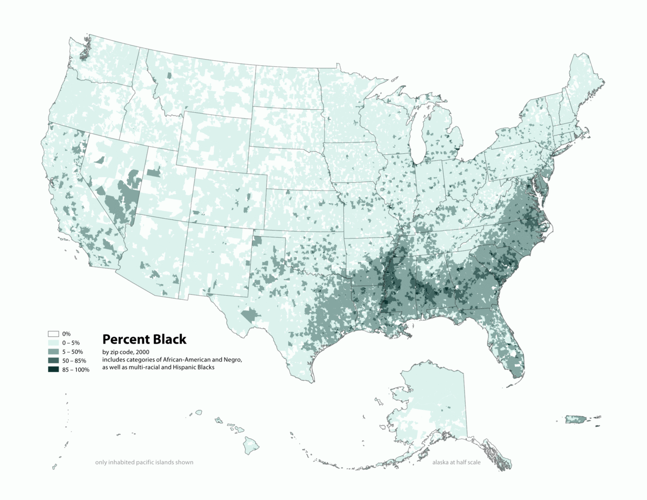
English: Map of contiguous US, showing percentage of population self-reported as "Black," by census tract, 2000. Data source: US Census. |
| Data | 3 april 2006 (original upload date) |
| Fonte | Transferred from en.wikipedia to Commons by O'Dea. |
| Autor | The original uploader was Citynoise at English Vicipedia. |
Lisensa
This file is licensed under the Creative Commons Attribution-Share Alike 2.5 Generic license.
- Tu es libre:
- per comparti – per copia, distribui e transmete la obra
- per remisca – per ajusta la obra
- Su la constrinjes seguente:
- atribui – Tu debe dona credita conveninte, furni un lia a la lisensa e indica esce on ia fa cambias. Tu pote fa tal en cualce modo asetable, ma no en un modo cual sujesta ce la lisensor aproba tu o tua usa.
- share alike – Si tu remisca, muta o developa plu esta obra, tu pote distribui la obra resultante sola su la mesma lisensa o un lisensa acordable con la orijinal.
Original upload log
The original description page was here. All following user names refer to en.wikipedia.
- 2010-05-01 19:15 Citynoise 2604×2012× (664072 bytes) Added Alaska, Hawaii, and Territories. Also changed from tracts to zip codes.
- 2006-04-03 02:04 Citynoise 1012×691× (78990 bytes) Map of contiguous US, showing percentage of population self-reported as "Black," by census tract, 2000. Data source: US Census. I am the designer and creator of this map and license it under the Creative Commons Attribution ShareAlike 2.5 License. s
Category:Census maps of the United States Category:Maps illustrating African American history Category:African American history
Istoria de fix
Clica un data/ora per vide la fix en sua forma de alora.
| Data/Ora | Imajeta | Mesuras | Usor | Comenta | |
|---|---|---|---|---|---|
| aora | 02:48, 31 desembre 2011 | | 2,604 × 2,012 (649 KB) | Spideog | {{Information |Description={{en|en:Category:Census maps of the United States en:Category:Maps illustrating African American history en:Category:African American history}} |Source=Transferred from [http://en.wikipedia.org en.wikipedia]; t |
Usas de fix
La paje seguente lia a esta fix:
Usa global de fix
La otra vicis seguente usa esta fix:
- Usa en af.wikipedia.org
- Usa en ar.wikipedia.org
- Usa en cs.wikipedia.org
- Usa en de.wikipedia.org
- Usa en diq.wikipedia.org
- Usa en en.wikipedia.org
- Usa en fa.wikipedia.org
- Usa en fr.wikipedia.org
- Usa en fy.wikipedia.org
- Usa en he.wikipedia.org
- Usa en ht.wikipedia.org
- Usa en incubator.wikimedia.org
- Usa en pt.wikipedia.org
- Usa en ro.wikipedia.org
- Usa en ru.wikipedia.org
- Usa en test.wikipedia.org
- Usa en tl.wikipedia.org
- Usa en ur.wikipedia.org
- Usa en uz.wikipedia.org